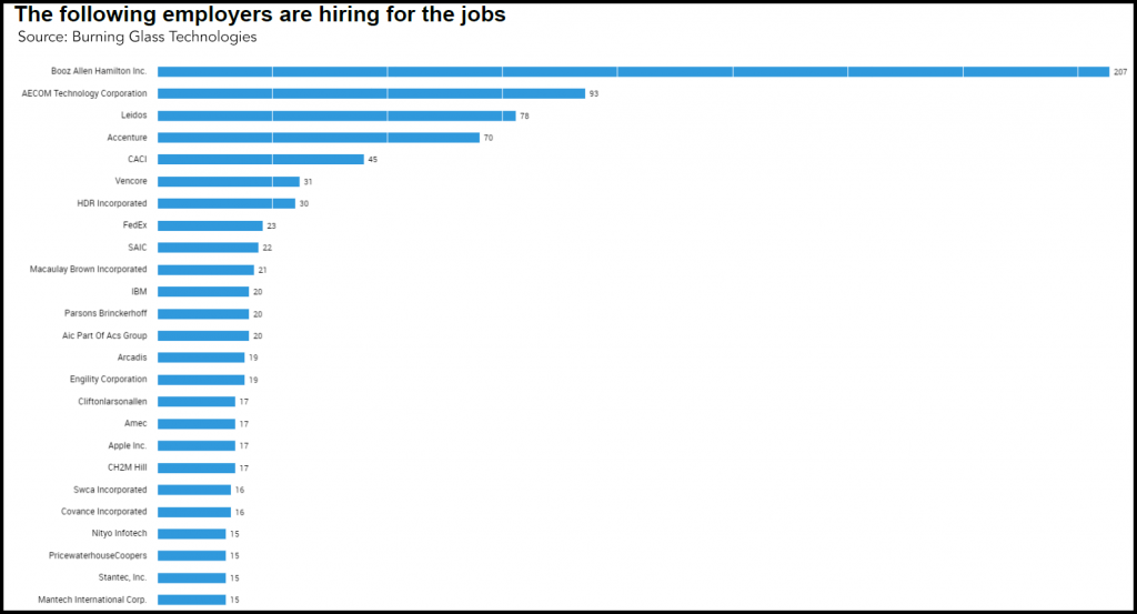
The GIS field offers many possibilities. In fact, geospatial technologies are being used in a wide variety of areas. Entering into this growing field generally requires a bachelor’s degree and a solid skill set. If you’re looking for a management role in the GIS field, however, most employers will require a master’s degree.
There are a variety of careers available in the GIS field. Some of the job titles you might find in this industry include:
- Geospatial Analyst/Technician
- GIS Analyst
- Geospatial Intelligence Subject Matter Expert
- GIS Administrator
- Resource Analyst
- GIS Director
- Remote Sensing Scientist/Technician
- Data Analytics Chief Scientist
A Socially-Focused Profession
GIS is rapidly making its mark in many aspects of society, especially social justice. For example, GIS was the cornerstone piece in a recent social justice activism project where tenants used digital mapping in order to combat eviction and displacement.
Other areas of society where one can expand their career in the GIS field are:
- Health
- City government
- Transportation
- Urban planning
- Business marketing
- Geology
- Archaeology
GIS permeates those parts of our lives that are often overlooked by the general population. For instance, GIS mapping technology is used to route emergency and fleet vehicles, determine the best places for businesses, and conduct demographic, market, and political research.
If this piques your interest and you’re wondering about the nuts and bolts of getting into the GIS field, keep reading. We flesh out these details to help you decide if a GIS career is a good choice for you.
Let’s dig into what you really want to know…
Will I Find a Job in the GIS Field?

The demand for GIS professionals continues to grow at a moderate rate. According to the Bureau of Labor and Statistics, the projected job growth for Geospatial Information Scientists and Technologists is 5-9% annually. Additionally, the report indicated that projected job openings average 22,400 through 2024. Furthermore, as of 2016, there were a total of 287,000 employed in this position nationally. The mean annual income for such a position sits at $88,510. The top industries for GIS-related professions include Government, Professional, Scientific, and Technical Services.
What Skills Do I Need?
 A day in the life of a GIS professional can vary depending on the landscape of the work environment. According to BLS.gov, the typical work you might expect to do as a Geospatial Information Scientist includes:
- Research or develop geospatial technologies
- Build databases
- Program applications
- Coordinate projects
- Specialize in areas such as agriculture, mining, health care, retail trade, urban planning, or military intelligence
- Produce data layers, maps, tables, or reports, using spatial analysis procedures or Geographic Information Systems (GIS) technology, equipment, or systems
- Provide technical expertise in Geographic Information Systems (GIS) technology to clients or users
- Perform computer programming, data analysis, or software development for Geographic Information Systems (GIS) applications, including the maintenance of existing systems or research and development for future enhancements
- Read current literature, talk with colleagues, continue education, or participate in professional organizations or conferences to keep abreast of developments in Geographic Information Systems (GIS) technology, equipment, or systems
- Lead, train, or supervise technicians or related staff in the conduct of Geographic Information Systems (GIS) analytical procedures
Do I Need to be a Tech Guru?
You will need to understand technology to be effective in this field because GIS is highly dependent on software to perform critical analysis. According to The Bureau of Labor and Statistics, some technological skills you will need to have or acquire to be effective are:
- Analytical or scientific software — ESRI ArcGIS Spatial Analyst; Landmark GeoGraphix; SAS ; The MathWorks MATLAB
- Database user interface and query software — National Land Cover Database NLCD; Soil Survey Geographic SSURGO; State Soil Geographic STATSGO Database; Structured query language SQL
- Development environment software — Adobe Systems Adobe ActionScript ; Formula translation/translator FORTRAN; List processing language LISP; Microsoft Visual Basic
- Map creation software — ESRI ArcGIS software ; ESRI ArcView; ITT Visual Information Solutions ENVI; Leica Geosystems ERDAS IMAGINE
- Object or component oriented development software — C++ ; Practical extraction and reporting language Perl ; Python ; R
What Kind of Degree Do I Need?
You will need at least a bachelor’s degree to get your foot in the door. However, if you aspire to move into a management position, you will need at least a master’s degree.
Next Steps
If you’re serious about a GIS career, consider getting additional educational experience under your belt. The Geographic Information Systems (GIS) Program at UMBC offers a Master of Professional Studies in GIS and a Post-Baccalaureate Certificate in GIS. The curriculum covers all aspects of the GIS profession, including web development and cloud computing, GIS application development, spatial databases, and enterprise systems implementation and management. The program is designed to equip you with the real-world skills that employers are looking for to help you jump-start your career in this exciting field.

When was this written? When was it updated?
It was written and published on May 27, 2018. All facts were taken from BLS.gov and Burning Glass, and are up to date.